Detailed Itinerary
Day 1: Arrival in Manali (2,050M)
The cycle expedition starts from Manali, which is a very popular tourist destination and hence extremely accessible. If you need guidance on how to get to this high-altitude backpacking center, this article (How to reach Manali) might come handy.
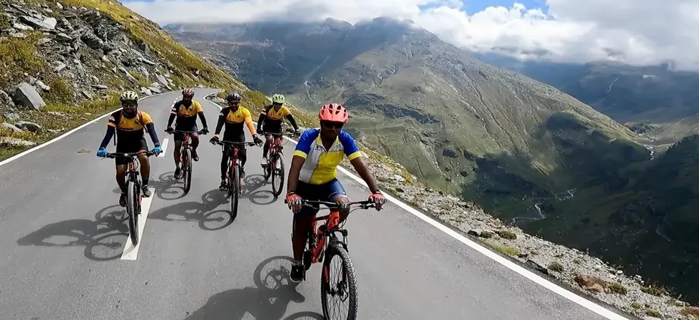
Day one is reserved for the participants to make their way into Manali and get settled into their accommodation in a Manali hotel. First half of the day is to get comfortable with the mountain air and our fellow riders. While the body acclimatizes, we take this time to get together with the group and delve into the happenings of the next few days – schedule, what to expect, route, basic do’s and don’ts, how to maintain the sanctity of the environment and such matters of importance. It is a relatively easy day but very essential for what’s to come next!
Day 2: Manali (2,050M) to Marhi (3,360M) (Click to View GPS data)
Distance: 37.5 km
Today marks the first day of our exit from Manali to ride towards our destination for the day – Marhi, which is a small town between Manali and Rohtang Pass. We are gaining 1,300M of altitude on our first day of riding in the mountains which can prove to be strenuous but is good preparation for the days to come. The route includes cycling up a series of hairpin bends on smooth, well laid-out roads. We also cross scenic mountain villages like Palchan, Kothi and Gulaba on our way today. We spend the night at Marhi which is just 16kms short of Rohtang pass. It offers some of the best views of the mountains in the Pir Panjal range of Himalayas.
Day 3: Marhi (3,360M) to Sissu (3,130M) via Rohtang La (3,978M) (Click to View GPS data)
Distance: 49.5 km
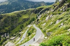
The day starts on a high as we ride the 16kms of slopes up to Rohtang Pass (3,978M). After waiting here for a bit to celebrate the crossing of the pass, to devour all the beauty that this high-mountain marvel has to offer, we start our journey onward. But not before we soak in all the gorgeousness of this terrain and the panoramic views of the snow-covered peaks in the region. The steady descent from Rohtang Pass is the definition of pure, unadulterated joy. This downward ride, with the breeze in your hair, takes you alongside Chenab River straight to Gramphu. From here we will encounter stretches of flat land as we cross the raging torrent of the river at Khoksar and continue the short and easy ride up to Sissu at the foothills of the Pir Panjal Range. Sissu (also known as Khagling) is a small town in the Lahaul valley of Himachal Pradesh. It is located on the right bank of Chenab River. This is where we spend tonight.
Day 4: Sissu (3,130M) to Udaipur (2743M) (Click to View GPS data)
Distance: 70 km
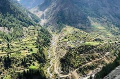
We continue our ride today alongside Chenab River on the Manali-Leh Highway all the way till Udaipur which is a small town 53 kms to the north of Keylong. It is most popular for the temple of Markula Devi, an incarnation of Goddess Durga. The route today is a mix of easy and moderate patches. The first five kilometers from Sissu are gradual ups and downs followed by a 12 km long downhill ride till Tandi Bridge. Tandi Bridge is at the confluence of two rivers – this is where the Bhaga River merges into the mighty Chenab River. The area is extremely picturesque. From here on, the trails run slightly uphill but it’s a gradual incline and hence remains manageable. The route changes to humps that take you up and down the smooth roads of the National Highway, all the way into Udaipur. You will see patches of green all throughout the way as we pass small villages along the way. It should take close to 6-7 hours of riding to get to our destination. We rest our weary selves for the day at our campsite which is a massive ground surrounded by tall trees in the middle of a forest, by the river.
Day 5: Udaipur (2,743M) to Purthi (2,287M) (Click to View GPS data)
Distance: 50 km
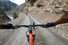
Today is an exciting day. Still riding alongside Chenab River, our constant companion on this expedition, we leave the smooth roads of the NH behind and turn this ride into a back-breaking off-road adventure. The route for today consists of continuous patches of gradual incline and descent. The road till 6 km before Purthi is fairly smooth but on an upward slope after which you will find yourself riding on kachcha trails up until the campsite. The trail takes us through multiple villages, border crossing and forests with tall Deodar trees. Its beauty lends to making this a breezy ride. The campsite for the day faces the village.
Day 6: Purthi (2,287M) to Killar (2,600 m) (Click to View GPS data)
Distance: 30 km
We continue our off-road adventure today from Purthi to Killar. With an approximate height of 315 M to be gained today, the trail alongside the river has gentle humps taking you up and down. The last 10 km to reach Khillar is a steady uphill ride. Killar, our destination for the day, is a small scenic village which takes you away from the river.
Day 7: Killar (2,600M) to Sach Pass (4,414M) (Section 1) (Section 2)
Distance: 74 km
Today, is going to be a very long and harsh day. We will leave our loyal companion, Chenab River to take its route while we make a diversion to go the other way. The pass lies at an altitude gain of almost 2000M covered across 40 km. The first 10 km out of Khillar is a downhill ride. The remaining route is all uphill on kachcha roads as you start to notice the tree line thinning out to slowly making an exit.
We lose all the altitude we had gained through the day as we make our downward journey back to Killar at 2,600M. The downhill climb requires some caution as it is an off-road route. Expect this day to be the longest yet as this 70 km ride is likely to take anywhere between 13-15 hours to complete.
Day 8: Killar (2,600M) to Bairagarh (2,149M)
Today we go further down to Bairagarh which lies at an elevation of 2,149M. On your way down, you start to notice the tree line making a reappearance.
Day 9: Bairagarh (2,149M) to Chamba (996M) (Click to View GPS data)
Distance: 80 kms
We cover a long distance today but it is fairly easy for we will mostly be going downwards from an altitude of 2,149M all the way down to Chamba at the elevation of 996M. Close to 70% of the ride today is downhill and we cross the same river multiple times to keep things interesting. There are only 10-15kms spread across the day with patches of uphill climb. The route is very scenic and the roads, smooth, putting today in the category of easy but fairly lengthy. Expect to cover the distance today in 8 hours.
Day 10: Chamba (996M) to Dalhousie (1,970M) (Click to View GPS data)
Distance: 44 km
Today is going to be hard but beautiful. Since a height gain of almost 1000M is on the agenda, it is going to be an uphill ride, through and through. After the first 30 Km, we reach the infamous open ground of expansive beauty at Khajjiar, which is regarded as the Mini Switzerland of India. From there on, the route gets more interesting by the kilometer. The ride up till Dalhousie is through thick forest lands that lead you directly into this popular hill station, which too wears the greens as its primary colour. Expect to reach Dalhousie within 6-7 hours of starting your ride.
Day 11: Dalhousie (1,970M) to Dukhar to McLeod Ganj (2,082M) (Click to View GPS data)
Distance: 57 km cycling + 69 Km Drive
The last day is a fairly straightforward one which goes by in a jiffy. Well, not really, but you know what we mean! The ride is smooth, the roads are smooth, and they all lead you into this neat town of Mcleod Ganj which is a spiritual hub and a very popular tourist destination with a lot to explore.