Brief Itinerary
Day 1: Briefing and Practice in Jagatsukh (1,951M)
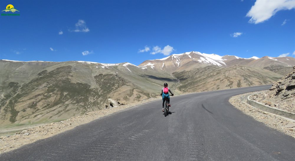
Day 2: Jagatsukh (1,951M) to Marhi (3,360M) (Click to View GPS data)
Day 3: Marhi (3,360M) to Sissu (3,130M) via Rohtang La (3,978M) (Click to View GPS data)
Day 4: Sissu (3,130M) to Jispa (3,200M) (Click to View GPS data)
Day 5: Jispa (3,200M) to Zingzingbar (4,270M) (Click to View GPS data)
Day 6: Zingzingbar (4,270M) to Sarchu (4,290M) via Baralacha La (4,850M) (Click to View GPS data)
Day 7: Sarchu (4,290M) to Whisky Nala via Nakee La (4,769M) (Click to View GPS data)
Day 8: Whisky Nala to Debring (4,835M) via Lachung La (5,059M) (Click to View GPS data)
Day 9: Debring to Lato (4,014M) via Taglang La (5,328M) (Click to View GPS data)
Day 10: Lato (4,014M) to Leh (3,500M) (Click to View GPS data)
Day 11: Leh (3,500M) to Khardung La (5,359M) to Leh (3,500M) (Click to View GPS data)
Day 12: Departure from Leh (3,500M)
Detailed Itinerary
Day 1: Briefing and Practice in Jagatsukh (1,951M)
Duration: 3 hours
Stay: Hotel
Upon reaching Manali and checking into our hotel, we spend the day at leisure and gear up for the briefing session in the evening. Information on how to reach Manali can be found here. In the evening, our expedition leader will take us through important details, safety and health pointers that we should bear in mind throughout the expedition. We are then introduced to our mountain bikes, which will take us all the way to Ladakh in the next nine days. The expedition leader then explains a few basics about the bike before we take it for a test ride.
It is important to get a good feel of the mountain bike before we begin our expedition in order to ensure that we have a smooth experience. In the event that you face any discomfort with the saddle or any other aspect of the bike, it is best to bring it to the notice of the expedition leader so that it can be adjusted to your needs. Once we are all back from the test ride and confident about our bikes, the expedition leader takes us through the route and how each day is going to look so that we have a broad understanding of what to expect.
Post this, we eat a fulfilling meal and get a long night’s sleep before we leave for what can be called an adventure of a lifetime!
Day 2: Jagatsukh (1,951M) to Marhi (3,360M) (Click to View GPS data)
Distance: 37.5 km
Duration: 8-9 hours
Stay: Dome Shape Tents
We start off our long expedition towards Ladakh around 9 A.M. after a heavy breakfast. Today, we cycle to Marhi, a small village on the way to Rohtang Pass, covering a distance of 37.5 km. We drive through the towns around Manali into lush green coniferous forests, taking the road that leads to Rohtang Pass. Today’s ride is challenging with the entire stretch being an uphill climb all the way to Marhi. It is important that we are thoroughly prepared to be able to complete the ride. There are chances of rain on this stretch, thus keeping our rain covers and gear handy prove to be useful.
As we climb through the turns and bends, we get a bird’s eye view of the towns below and panoramic views of the Himalayas. Numerous seasonal waterfalls can be seen on the mountains as a result of recent rainfall or melting snow from higher up. The scenery we encounter today is a treat to the eyes with bright green from the forests, dark blue from the skies and the foaming white from the waterfalls creating a colorful palette to enjoy.
Since we gain a significant amount of altitude today, it is extremely important that we remember to hydrate and eat sufficient food in order to allow our bodies to acclimatise properly.
We reach Marhi around 5 in the evening. The tents would have been set up; hot snacks await us after a long day’s ride. We spend the evening with our fellow riders and get ample rest for tomorrow’s challenge.
Day 3: Marhi (3,360M) to Sissu (3,130M) via Rohtang La (3,978M) (Click to View GPS data)
Distance: 51 km
Duration: 6-7 hours
Stay: Camping
Today we encounter our very first high mountain pass in this expedition! We ride 16 km up from Marhi to Rohtang Pass (3,980 M) and then 23 km down to reach a small village, where we stop for lunch. From there, it is a gradual 12 km with small ups and downs all the way to Sissu. Today is comparatively easier with a long patch of downhill cycling and also the gradual bits. However, the initial climb to Rohtang Pass can be challenging given the altitude gain. Although the ascent is not too steep, the air gets thinner here, making it difficult to perform strenuous physical activities.
The landscape remains green almost until we reach Rohtang top. But as we keep moving higher up, we can notice the reduction in treeline and the increasing appearance of dry mountains. At Rohtang top, we get panoramic views of snowcapped peaks in the distance who do their bit to remind us how far we have come. We stop here for a few minutes and move on to the most thrilling part of today’s ride. The downhill ride is easy on the legs and the stretch is completed rather quickly. Make sure to enjoy it while it lasts as we glide through towering mountains that surround us. It is however important to be in control of the mountain bike on downhill patches. As easy and enjoyable as it might seem, we should be able to halt the bike if required and slow down at the bends in order to avoid any mishaps.
We break for lunch a little past a checkpost at Koksar, which marks the end of the descent. We continue our journeyto Sissu after recharging ourselves with a heavy lunch. Sissu is located in the Lahaul and Spiti district of Himachal Pradesh. We reach Sissu between 4-5 P.M. having cycled a long distance today. Our stay for the night will be in Swiss tents with beds and blankets to keep us warm.
Day 4: Sissu (3,130M) to Jispa (3,200M) (Click to View GPS data)
Distance: 55 km
Duration: 6-7 hours
Stay: Hotel
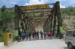
It might feel difficult to get out of the warm blankets but today’s journey is absolutely worth it! We cycle from Sissu to Jispa, through Keylong and cover a distance of 55 km. Jispa is a quiet village with just a handful of houses and stores with basic supplies. The first stretch till Tandi is easy, starting with around 10 kms of gradual ups and downs and then 15 kms of downhill riding. Notice how the dry terrain has fully taken over the landscape, hinting that we are slowly entering the cold desert region. The remaining distance is predominantly an uphill climb with 7 kms of downhill right before we reach Jispa. Today’s ascent is difficult and can be extremely challenging in the scorching sun. As always, it is important to keep hydrating and taking small breaks to have snacks in order to maintain your energy levels.
We ride through Keylong with the dry mountains accompanying us throughout. As we are nearing Jispa, Mt. Lady of Keylong comes into sight on our right side. She is a majestic 6000M peak and is a favourite among mountaineers.
We reach Jispa around 3 in the afternoon. Our stay for the night is at a local homestay with comfortable beds and blankets. We also have access to attached bathrooms and hot water to freshen up. We spend the evening having hot snacks, enjoying the landscape and also giving our legs some much needed rest.
Day 5: Jispa (3,200M) to Zingzingbar (4,270M) (Click to View GPS data)
Distance: 36 kms
Duration: 7-8 hours
Stay: Camping
We leave for Zinzingbar after a good night’s sleep at the homestay and a sumptuous breakfast. Today is going to be exciting but also physically strenuous at the same time. A significant part of the stretch is an ascent, some of it steep and the rest of it gradual in nature. The 6 km ascent to upper Zingzingbar to reach our campsite for the night is the most challenging, especially at that altitude under the direct heat of the sun. Hydration is key and so is finding your rhythm to be able to complete the stretch comfortably.
We pass through Darcha, a small town with a checkpost and local dhabas. We make our way further up the Manali-Leh highway to reach Deepak Tal, a pristine blue lake nestled amongst the dusty mountains. We break here to get some rest and snack on something before moving on to Zingzingbar. The road curves along the Bhaga river with the arid landscape becoming all the more prominent. On clear days, the skies are deep blue with not a cloud in sight, almost as if someone forgot to paint them.
We stop for lunch at lower Zingzingbar and get ready for the final ascent for the day. We reach upper Zingzingbar around 5 P.M. and treat ourselves to the hot snacks prepared for us. We spend the night in tents and gear ourselves up for the ride to the second high mountain pass in the expedition!
Day 6: Zingzingbar (4,270M) to Sarchu (4,290M) via Baralacha La (4,850M) (Click to View GPS data)
Distance: 50 kms
Duration: 7-8 hours
Stay: Swiss Tents
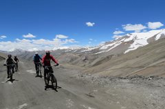
The second high mountain pass of the expedition, Baralacha La, awaits us at a massive height of 4,850M! We make our way from upper Zingzingbar to reach Baralacha La, which is a long ascent of 16 kms on our mountain bikes. From the pass, we are faced with an adventure-filled downhill ride, through off roads and streams that breach the highway all the way to Sarchu. The road conditions today keep varying with well laid roads in some parts and roads which are under construction or maintenance in others. Cycling, particularly downhill, on offroads could be extremely challenging given the pieces of gravel that are strewn around. It is important to be mindful of the road and maintain balance in such conditions.
As we cycle to Baralacha La, we get to see the grandeur of the mountains around us. We have come a long way and also have a long way to our destination! The views from Baralacha La are breathtaking to say the least. We make a quick stop there before moving on. A little before Baralacha La, we come across Suraj Tal, another Himalayan lake nestled amidst the mountains with their perfect reflections visible in the water. In early June, the lake can be seen in its full beauty due to the remnants of the snow on the mountains, making the reflections all the more stunning.
It can be noticed that there is a variance even within the arid landscapes. The texture and colours of mountains, their shape and even structure keeps varying as we move ahead. The feeling of our mountain bike gliding through the vast open landscape towards Sarchu is inexplicable. Massive mountain ranges as far as the eye can see. We ride to Sarchu absorbing every bit of this.
We reach Sarchu around 4 P.M. in the evening and settle into our Swiss tents. Once again, we are greeted with warm beds and blankets! Get sufficient rest, for tomorrow we enter into Ladakh.
Day 7: Sarchu (4,290M) to Whisky Nala via Nakee La (4,769M) (Click to View GPS data)
Distance: 48 kms
Duration: 7-8 hours
Stay: Dome Shape Tents
Today is full of exciting adventures and challenges! We make our way from Sarchu into Ladakh, cross the Gata Loops, ride through the third high mountain pass of our expedition, Nakee La, to reach Whisky Nala! The 22 km stretch from Sarchu to the beginning of Gata Loops is a rather flat one with a fair amount of descent and a few ascents here and there. We are then faced with an uphill climb through the 21 Gata Loops to reach Nakee La at 4738 M. From there to Whisky Nala is a gradual descent into the valley. The climb up to Nakee La is extremely challenging given the gradient and the altitude. Once again, rhythm becomes crucial in helping us ride our way to the top.
We enter Ladakh after crossing two checkposts, just a little after leaving Sarchu. Sarchu is a bordertown between Himachal and Ladakh. The striking scenery continues to accompany us throughout with clear blue skies. Workers can be seen on the sides of the road greeting us or wishing us luck for our adventure. The road through Gata Loops is narrow and it is important to be mindful of the traffic, given the number of trucks that pass through this highway. As we complete the Gata Loops and cycle our way to Nakee La, look out for blue sheep which are found in herds in this region!
We reach Whisky Nala around 4 P.M. where our tents and hot evening snacks await us. Given that Whisky Nala is located at a height of 4,600M, people are often faced with issues of Acute Mountain Sickness (AMS). This largely happens due to improper acclimatisation or lack of hydration. It is essential to consume 5-6 litres of water every day. In the event that you are faced with any suffocation, the expedition leader must be promptly informed. Get as much rest as possible in order to help your muscles recover.
Day 8: Whisky Nala to Debring (4,835M) via Lachung La (5,059M) (Click to View GPS data)
Distance: 81 kms
Duration: 8-9 hours
Stay: Dormitory
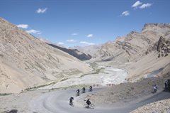
The road to Debring is a long one, requiring us to cover 81 kms in one day. We are first faced with a 7 km ascent to Lachung La, after which the road winds down all the way to Pang. Pang is a small settlement with locals providing beds and food to travellers who wish to halt. At Pang, there is a short climb of 5 kms to reach the starting point of More Plains. More Plains is one of the most exciting parts of this expedition with close to 45 kms of flat stretch, thus letting us relax and soak in the scenery around. The gradient remains the same all the way to Debring, with a small patch of ascent right before we reach the campsite. The day is challenging nonetheless given the distance covered and the strong winds in More Plains.
The road to Lachung La and beyond largely consists of offroading. We do not encounter perfectly paved roads almost until we reach More Plains. The landscape and the views more than make up for it and make the ride an exciting one. The journey through More Plains is a smooth one through easy roads and vast open landscapes around us. We can now see the “cold desert” right in front of us and understand what the term truly means!
We reach Debring around 5 P.M. and get some much needed rest after an extremely long day. Relish the sumptuous meals and rest for the night.
Day 9: Debring to Lato (4,014M) via Taglang La (5,328M) (Click to View GPS data)
Distance: 53 kms
Duration: 5 hours
Stay: Dome shape tents
By now we are familiar with the route. We know that if we climb up to a mountain pass, a long thrilling descent awaits us. We leave from Debring to Lato via Taglang La, which is at a height of 5,328M! It is currently the third highest motorable mountain pass in the world. We are faced with a 22 km ascent from Debring to Taglang La before we hit the downward winding roads that take us to Lato. The climb to Taglang La is difficult with the air getting thinner in addition to the long steep ascents that it entails. The descent to Lato through Rumtse is an easy one but always remember the rules of downhill cycling!
The views from Taglang La top are spectacular to say the least and accompany us as we make our way down. Prominent peaks such as Mt. Nun, Mt. Kun and even Kang Yatse are visible from the top. As we reach Rumtse we notice a sudden change in the colour and texture of the mountains. There is little scree visible unlike the landscape that we saw until now. The mountains have a shade of brick red with a tinge of olive green flowing through them. These views are unlike anything we have seen so far in the expedition!
Lato is just a little ahead of Rumtse. We arrive at our homestay where beds and blankets await us along with hot lunch! We rest for the day and prepare ourselves to ride to Leh the next morning.
Day 10: Lato (4,014M) to Leh (3,500M) (Click to View GPS data)
Distance: 70 kms
Duration: 6 hours
Stay: Hotel
The day has finally come where we ride to Leh! Although the distance appears to be long, it is relatively easy with just a handful of ascents in an otherwise flat stretch. The initial bit through the red and green mountains is fairly simple although it consists of blind turns and dug up roads here and there. We are finally back in civilization. We make our way to Leh through small towns and army bases.
The river Indus flows on our right as we reach Upshi. On our way, we reach the famous Thiksey Monastery. While we do not have the time to enter the monastery, we make a quick stop to appreciate the exteriors. We also pass by Shey Palace before we enter the city of Leh.
We reach Leh by late afternoon time and check into our hotels. The rest of the day can be spent exploring Leh markets and local food. However, we still have one last challenge ahead of us so it’s also important to get ample rest!
Day 11: Leh (3,500M) to Khardung La (5,359M) to Leh (3,500M) (Click to View GPS data)
Distance: 40 kms
Duration: 7 hours
Stay: Hotel
We are now faced with the ultimate challenge of the expedition, the ascent to Khardung La, the second highest motorable road in the world at a staggering height of 5,359 M! The route is a steep ascent of 45 kms all the way to Khardung La and is extremely challenging in nature with a height gain of 2000 M. AMS is quite common on this patch and hence hydration continues to be crucial to get through. It is also important to remember to cycle at your preferred pace in order to avoid exhaustion.
The top offers you a bird’s eye view that stretches from the Indus valley in the South over the endless peaks and ridges of the Zanskar range to the giants of the Saser Massif in the North. Khardung La top is usually thronged by tourists from Leh wanting to get a picture clicked at one of the world’s highest motorable passes. There is also a small cafe and souvenir shop if you wish to take any memorabilia back home. We then make our way back to Leh in our backup vehicle after loading our cycles in. Expect to reach by late evening. The trip ends here but not before celebrating this massive achievement.
Day 12: Departure from Leh (3,500M)
If you plan to stay for a few more days to explore the wonders of Ladakh, the article below might help start you off on what places to consider. (Places to visit in Leh Ladakh)
Like we indicated before, the weather on high-altitude is unpredictable as are many other conditions. We would suggest you keep spare days between the end of the expedition and your travel arrangements to head back home.