Rishikesh to Pipalkoti
- Altitude: 1,340 m/ 4,400 ft.
- Drive Distance: 200 km.
- Driving Time: 9-10 hrs.
- Pick up from Rishikesh TTH office 06:00 am.
- Driving Time-9-10 hrs.
- The last ATM point is available in Pipalkoti.
- Market available in Pipalkoti.
- Networks are available all along the way.
- Guest house stay (Shared Accommodation).
You will begin your journey with us from Rishikesh. Starting the drive from Rishikesh from the appointed pickup point TTH office in Tapovan, we will take the fabled Badrinath Road.
The nine-hour drive to Pipalkoti will surely be long and arduous, but you are never going to run out of mesmerizing views. The great river running with us on parallel will get wilder and more fascinating as we trudge uphill. We will pass by 4 of the Panchprayag or the holy confluences of Ganga—Devaprayag, Rudraprayag, Karnaprayag, and Nandaprayag. So, keep your cameras ready and remain awake for most of the journey!
Drive From Pipalkoti To Govindghat - Pulna and Trek to Ghangaria
- Altitude
Pulna: 2100 m/ 6900 ft.
Ghangharia: 3,000 m/ 9,800 ft.
- Drive Distance (Pipalkoti to Govindghat): 52 Km | 2 hours.
- Then Dirve Govindghat to Pulna in Local Union Transport 4km in 15min.
- Trek Distance (Pulna to Ghangharia): 9 km | 4 hours.
- Gradual ascent on a stone-paved path, all the way along the river.
- Water is available along the route.
- Hot lunch will be given on the way.
- Mule and porter facilities are available from Pulna.
- BSNL, JIO, and AIRTEL networks are available at Ghangaria.( Erratic network)
- Helicopter service is available from Govind Ghat to Ghangaria and only if the weather allows (Not included in cost).
- Stay in a guest house (Shared Accommodation).
Noteworthy Site: Govinddham Gurduwara, Govindghat; Hemkund Gurduwara base, Ghangharia; Valley of Flowers Information Center; Ghangharia.
Pipalkoti to Govindghat the distance is 52 km. En route, you can spot the final confluence - Vishnuprayag. We will start in the morning after breakfast and reach Govindghat by 8 am and then a 4 km drive to Pulna which is the starting point and included in the trek cost. Then your trek will be 9 km uphill along the river, Pushpawati. The entire trail will be crowded most of the time. Many snack shops selling beverages, hot noodles, omelets with bread, paratha, and the like can be found on this trail. So, you will never go hungry.
The trek will be on a clearly defined stone-paved path, conveniently built with stairs. After a 5 km walk, you will arrive at Bhyundar village. This village marks an amazing viewpoint for clear Hathi Parvat sights. Enjoy the wonderful sight as much as you can, because the strainful steep ascent will commence henceforth. You will reach Gangharia before nightfall, attaining an altitude of 9,800 feet. The stay will be at a guest house.
Ghangaria to Valley of Flower and back to Ghangaria
- Altitude: 3,500 m/ 11,500 ft.
- Trek Distance- 4 km, each way | 7hrs.
- The Valley is 6-7 km long and ends with a glacier.
- Mixed incline till the valley followed by a level walk on grassland.
- Can refill water bottles from streams on the way.
- A packed lunch will be given, no food is available in the valley.
- Camping inside the valley is not allowed, can’t stay after sunset.
- Night stay in Guest house (Shared Accommodation).
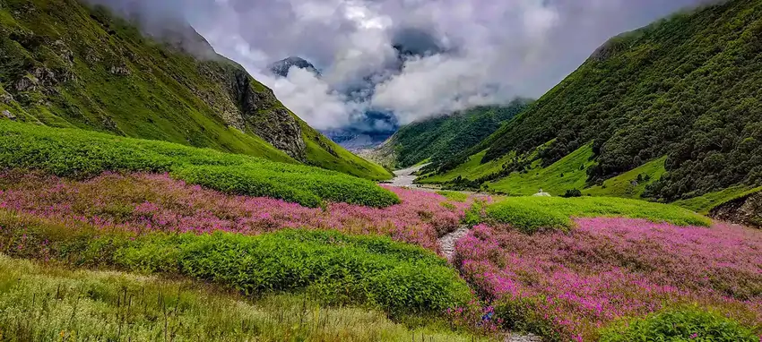
Prominent flowers: Blue Poppy, Snake Foil, White Leaf Hog Foot, Himalayan Rose, Meadow Geranium, Dog Flower, Hooked Stick Seed, and River Anemone.
The journey to Valley of Flowers is a distance of 4 km. The valley is 6-7 km long; the distance travelled in the valley depends on how the trekkers want to explore the valley. Another, factor to be considered is the stamina of the trekkers.
Right, when you start from Ghangaria in 30 minutes forest check post arrives. The check post might not be an attraction but right before the check post, there is a gushing waterfall called Laxman Waterfall. Another 20 minutes into the greenery and the next furious attraction comes. At this point, the Pushpavati River flows furiously below a wooden bridge. It is quite a common yet unique and mesmerizing capture. The trail is steep and stone paved like the previous day. You can find many bridges and landslide areas when you enter the valley.
The valley is thousand times more stupendous than you might have imagined. It truly makes the Himalayan peaks lively and cherishing. Blue Poppy, Snake Foil, White Leaf Hog Foot, Himalayan Rose, Meadow Geranium, Dog Flower, and Hooked Stick Seed are the native flowers. These astounding colourful blossoms end after a 5 km stretch at a glacier. If the weather is clear the mighty Himalayan peaks of Nilgiri Parvat, Bhyundar Khal, Rattaban, Gauri Parvat, etc. in the background. Today’s journey will conclude with your coming back to Ghangaria before nightfall.
Ghangaria to Hemkund Sahib and back to Ghangaria
- Altitude: 4,300 m/ 14,100 ft.
- Trek Distance: 6 km, each way | 8-9 hours.
- Gradual and steep mixed ascent on a stair-welled stone-paved path.
- Mule ride service is available till Hemkund Sahib.
- Can refill water from roadside dhabas.
- Hot lunch at Gurduwara langar.
- Brahma Kamal, a Himalayan blue poppy can be seen on the way to Hemkund Sahib.
- Night stay in Guest house.
Get ready early in the morning to start trekking (6 Km) for Hemkund Sahib. One of the most revered of all Sikh shrines and the world’s highest Gurudwara, Hemkund Sahib, is situated at an altitude of 4,329 meters. There will be porters and mules if you wish to offload your load. The trail today will be similar to previous days, stone-paved and continuous ascend. There will be shops on the way where you can energize yourself. Watch out for the rare flower Brahmakamal that will be spotted beside pathways.
The Gurudwara is placed magically beside the mirror-like glacial lake Hemkund. During clear skies, one can witness the flawless reflections of the adjoining Saptrishi peaks. The lake is fed by the melting glaciers of Hathi Parvat and Saptrishi peaks. Religious Laxman temple is also found near the lake. In the afternoon trek down to reach Ghangariya for an overnight stay. The evening is free for rest & relaxation.
Ghangaria to Govindghat and Drive to Pipalkoti (Badrinath optional)
- Trek Distance (Ghangharia- Pulna): 9 km | 4-5 hrs.
- Drive Distance (Pulna- Govind Ghat): 4km | 15min.
- Drive Distance( Govind Ghat- Badrinath): 25km | 1 hr.
- Drive Distance (Badrinath-Pipalkoti): 75km | 3-4 hrs.
- Packed lunch.
- Guest house stay.
GovindGhat to Badrinath is a landslide-prone area in monsoon time so if our leaders find that your safety is at risk due to weather conditions/ landslide or road blockage then we shall skip Badrinath altogether and drive to Pipalkoti directly.
After your breakfast in the morning, we descend to Govindghat and then drive to Pipalkoti. From this place, Badrinath is 25 km away and takes 1 hrs to reach. You can visit Badrinath only if road and weather condition permits us.
On arrival, check into the hotel. Overnight stay is arranged in a hotel.
Pipalkoti to Rishikesh
Drive Distance: 200km | 9-10km.
The ride will commence at 6 am and you will reach Rishikesh around 5 - 6 pm. Your Breakfast and Lunch will be on the
way at a roadside inn, exclusive of charges, after having your morning tea/coffee you can leave for your next
destination.